 |
|
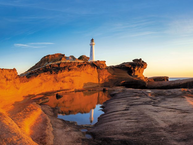
Castle Point Lighthouse |
Castle Point Lighthouse, Deliverance Cove, Castle Point Scenic Reserve
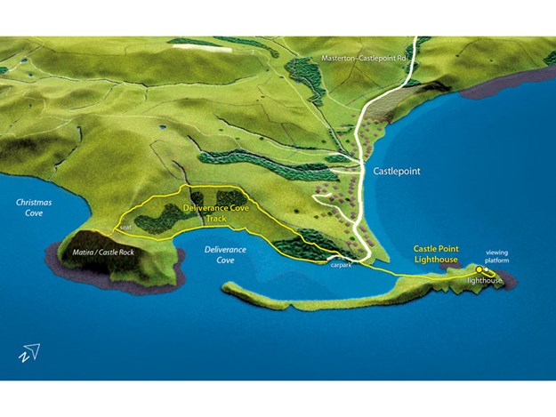
No other coastal landform in New Zealand is remotely like Castlepoint, and it’s the most scenic of all the Wairarapa’s many interesting coastlines. The Castle Point Lighthouse perches atop an old limestone reef, raised out of the sea like an upturned ship hull.Southwards, the reef forms a low protective barrier against the surf, almost encircling the aptly named Deliverance Cove, through which many a fishing boat has retreated to safety from heavy seas. And above it all rises the monolithic Matira/ Castle Rock – a coastal knoll flanked by eroded cliffs.
The walk to the Castle Point Lighthouse suits walkers and families of all abilities, although parents should watch their children closely around cliff edges. Fishing boats, launched on large and specially designed trailers with very long drawbars, form another interesting aspect of the area.
Adjacent to the scenic reserve is the small Castlepoint beach community; once a place of modest baches, now a popular holiday spot with some palatial homes. A campground and shop service visitors and locals alike.
Car park to Castle Point Lighthouse: 30 minutes return
From the car park, cross the sandy isthmus to a bridge that straddles the channel out of Deliverance Cove. A well-graded concrete path leads up a gentle slope to the prominent lighthouse, built in 1913. Above the lighthouse, a set of wooden stairs leads to a viewing platform with a fine vista of the coastline north and south. Stairs continue to loop around the headland among coastal vegetation back to the lighthouse. Keep an eye out for shellfish fossils.
Deliverance Cove Track: 1.5 hours return
Walk around the sandy shore of Deliverance Cove to where an obvious but unmarked trail leads into the dunes at the base of Castle Rock. From here the trail climbs uphill over grassy slopes, reaching a small saddle, where there is a wooden seat with views of Deliverance Cove to the north and Christmas Cove to the south.
A DOC sign here warns that the unofficial route up Castle Rock is not maintained and dangerous. Nevertheless, it’s very popular with holidaymakers visiting Castlepoint. It climbs, reaching an outstandingly spectacular, airy view near the cliff edge. Above, the well-worn trail keeps west, away from the unstable cliff edge, to emerge onto the flat grassy summit of Castle Rock (162m).
Stay away from the edge - a fall from here would be fatal, and the route is definitely not recommended in windy conditions, or for small children, or those with vertigo. Back at the wooden seat, a benched track leads around the edge of farmland, through areas replanted with native shrubs in recent years. The track descends through pines to reach the car park.
- Grade: Easy (lighthouse), Hard (Castle Rock)
- Total walking time: 2–2.5 hours return (combining both walks)
- Access: From the northern outskirts of Masterton, turn right onto Te Ore Ore Road, following signposts to Castlepoint. The road becomes the Masterton– Castlepoint Road, which ends at the beach. Allow an hour for the 50km drive from Masterton, which is windy in places.
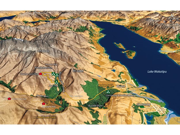
Glenorchy Scheelite Huts, Whakaari Conservation Area
Most people who visit Glenorchy, the township at the head of Lake Wakatipu, are headed for Mount Aspiring National Park, perhaps for a walk on the famous Routeburn Track, a jetboat trip up the Dart River or to tramp the Rees–Dart Circuit.Many don’t realise that rewarding walks exist right near the township, in the Richardson Mountains, notably to a network of rustic huts used in the fascinating scheelite-mining period. Scheelite is an ore of tungsten, a soft metal important in the munitions industry, and the fortunes of Glenorchy’s hardy scheelite miners rested squarely on what was happening in the wider world.
During times of war, mining was profitable; during peace time, not so much. The Richardson Mountains are a hard, high place, especially in winter, so the miners needed shelter. Because the century-long mining period lasted as late as the 1980s, many of the huts have survived, and DOC has in recent years done a wonderful job of restoring several of them.
The huts are located in two main groups: those on the flanks of Mt Alaska in the headwaters of Bonnie Jean Creek, and those on the flanks of Mt McIntosh, on the opposite side of the Buckler Burn. Three (Heather Jock, McIntyre and McIntosh) are available for overnight stays.
This walk makes an interesting circuit around the huts in the Bonnie Jean catchment, and will occupy a full day. Those wanting a shorter walk can turn back at Jean Hut (4–5 hours return) or simply visit the Glenorchy Scheelite Battery (1.5–2 hours return). Take plenty of sun protection in summer; during winter you may need an ice axe and crampons.
Wyuna to Bonnie Jean Hut via Judah Track: 3–4 hours
The Judah Track at first climbs through dry farm country, near the torrid Buckler Burn, to join the old mine vehicle track after 30 or so minutes. After another 15 minutes, the track leads up to the Glenorchy Scheelite Battery site, which was the main processing plant for ore transported down from the mines in the mountains above.
Much of the machinery has been restored, and you can also poke your nose into the mine manager’s hut. The main route continues up the vehicle track, which climbs at a steady, even gradient, eventually rounding a lower shoulder of Mt Judah, where there are views into the headwaters of Bonnie Jean Creek and Mt Alaska high above.
To the north are views of Mt McIntosh, and the keen eye might even spot some of the huts there. The country is largely open and barren with tough, spiky plants, but beech forest cloaks much of the Buckler Burn below. At ‘the Junction’, a track heads left into the Buckler Burn towards Mt McIntosh. Stay on the Judah Track.
After another 40 minutes, at a signposted junction, a track branches off to Jean Hut (where you will return from later). Continue up the narrowing Judah Track for 20 minutes to where it intercepts Bonnie Jean Creek.
Here, take a short 2-minute side trip up to one of the historic huts - Boozer - named after a miner with a fondness for liquor. Across the creek, the track zigzags for a further 10 minutes up to the site of the Bonnie Jean mine and hut (day-use only). Inside, much of the miners’ machinery and tools remain, displayed as an onsite museum.
Bonnie Jean Hut to Heather Jock Hut (3 bunks): 40–60 minutes
From Bonnie Jean Hut, the track climbs stiffly, then begins a more gentle sidle, rising to finally reach the 15-minute side-track leading to the top hut in the valley - Heather Jock. This has a fine perch at 1320m with an expansive vista over the Buckler Burn and the Richardson Mountains, with the more distant Mt Earnslaw/Pikirakatahi beyond. Trampers with overnight gear can stay here, and there’s a tank for water.
Heather Jock Hut to Jean Hut: 60–90 minutes
From Heather Jock Hut, head back to the last track junction, and then head right (north) in the direction of Jean Hut. The track, marked by poles, makes a series of zigzags down the steep hillside, dropping more than 400m quickly to reach the historic Jean Hut, which was built during the First World War.
This small, dark hut has the curious feature of large rocks, hanging either side of the hut by cables, as a crude but effective way of securing the roof against the worst winds. From Jean Hut, a short 10-minute track links back with the main Judah Track, from where it’s a downhill plod back on your inward route.
En route, you might like to visit the remains of the State Mine, the oldest and longest-worked of all the scheelite mines. It was called the State Mine because the government ran it to ensure tungsten supply for the British effort during the Second World War, when production of scheelite ore peaked.
- Grade: Medium–Hard
- Total walking time: 6–8 hours
- Access: From Queenstown, drive for nearly an hour along the Glenorchy– Queenstown Road to Wyuna, 3km before reaching Glenorchy. At the carpark, there are toilets, information panels and a small shelter. Keep to the track, which crosses private farmland at first. Alternative route: Another full day could be spent exploring the huts using the McIntosh Loop Track.
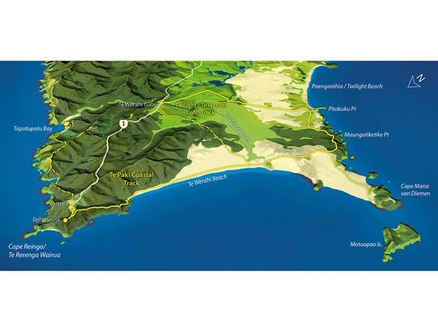
Te Paki Coastal Track, Cape Reinga/Te Rerenga Wairua
 |
|
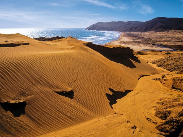
Sand dunes at Cape Reinga |
Now, only the islands around Cape Maria van Diemen remain separated. The cape is of immense importance to Māori, who know it as Te Rerenga Wairua, or the leaping place of the spirits.
Here, souls of the deceased depart Aotearoa to begin their long journey back to the ancestral homeland of Hawaiki. Contrary to popular opinion, Cape Reinga is not the northernmost tip of New Zealand’s mainland; that title belongs to Hikurua/de Surville Cliffs of Otou/North Cape, which lies to the east and a full 2km closer to the equator.
While most of the hundreds of thousands of people who visit the cape are content to wander the short sealed path to the lighthouse and gaze over the turbulent waters at the meeting of the Tasman Sea and Pacific Ocean, more adventurous walkers will find a rewarding loop track to Cape Maria van Diemen and Paengarēhia/Twilight Beach.
The route crosses some of New Zealand’s most distinctive and expansive coastal scenery. It is also the start of a 3000km-long journey for trampers setting off to walk the length of the country on Te Araroa, New Zealand’s Trail.
Cape Reinga to Cape Maria van Diemen turnoff: 2–2.5 hours
Branching off the path to the lighthouse, a well-benched track descends for 30 minutes beside coastal cliffs to the long sweep of Te Werahi Beach. After following the coast southwards for 45–60 minutes, the track reaches a junction with the northern part of the Twilight–Te Werahi Loop Track (a possible exit route to Cape Reinga Road).
After crossing Te Werahi Stream (sometimes impassable above mid-tide), Te Paki Coastal Track heads inland up grassy slopes to colourful dunes beyond, dominated by the native sand grasses, pīngao and spinifex.
A gentle climb leads over the flanks of Herangi Hill (159m) to a signposted track junction, which offers fine views of Cape Maria van Diemen and its offshore islands. On a clear day the 90-minute return side-track leading to the cape is well worthwhile.
Cape Maria van Diemen turnoff to Twilight Beach and Cape Reinga Road: 2.5–3 hours
From the track junction, the main walkway enters coastal shrublands, dominated by prostrate mānuka, traversing a broad ledge above the cliffs of Maungatiketike and Pitokuku points before descending through lupins towards Twilight Beach. From a signposted track junction, the 5-minute walk to Twilight Beach is worthwhile.
Back at the junction, head inland through a vast area of dunes, where there is some curiously charred and eroding rock exposed in places. Here, large orange squares atop tall poles indicate the route at intervals. A short section of dense lupins leads to a sidle through twisted mānuka forest and out into the open again beside an extensive wetland in Te Werahi Valley.
The track crosses a narrow neck of the raupō-dominated wetland on a boardwalk to a final mānuka stand before reaching farmland. Across a stile, poles lead up grassy slopes to a farm ridge, which is followed to Te Werahi Gate on Cape Reinga Road. Walkers can choose to walk the 4.5km of road back to the cape or prearrange a shuttle pick-up.
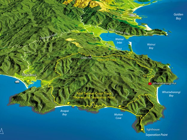
Anapai Bay to Separation Point: 1.5 hours
After departing Anapai Bay, the track skirts more beaches and rocky headlands to reach the Mutton Cove campsite in 30 minutes. Here, the main Abel Tasman Coast Track heads inland towards Whariwharangi Bay. Ignore this, and instead take the track heading north, which climbs briefly around one headland then follows the Mutton Cove shoreline.
At the north end of the beach, the track climbs through forest dominated by kānuka up to the ridgeline. At a signposted junction, take the track to Separation Point. Shortly beyond, a viewing area offers a vista of the headland and its small automated lighthouse.
On a rough route, weaving through coastal flax, it’s possible to scramble down to the point. Kekeno, mainly adult males or juveniles, migrate here from other breeding colonies to overwinter. A few stragglers sometimes remain during summer. Avoid approaching the seals too closely. In contrast, you can confront the local gannets; they are made of concrete in an unsuccessful attempt (so far) to attract real feathered ones to the site.
- Grade: Easy–Medium
- Total walking time: 4.5–5.5 hours return (excluding the 90-minute side trip to Cape Maria van Diemen and the section of road between Te Werahi Gate and Cape Reinga)
- Access: From Kaitaia take SH1 north as far as it goes. Allow 90 minutes’ drive for the 111km section of road, which was sealed all the way in 2010. Near the cape is a car park, toilets and information panels. Alternative routes: Walkers can begin from the Cape Reinga Road on the northern section of the Twilight–Te Werahi Loop Track, which descends directly to Te Werahi Beach without passing the section at Cape Reinga. Another shorter alternative is a return trip from Cape Reinga to Cape Maria van Diemen. East of Cape Reinga, a pleasant walk leads to Tapotupotu Bay and a car park and campsite there (allow 90 minutes each way). Further south, off Cape Reinga Road, the enormous sand dunes at Te Paki are also a rewarding visit.
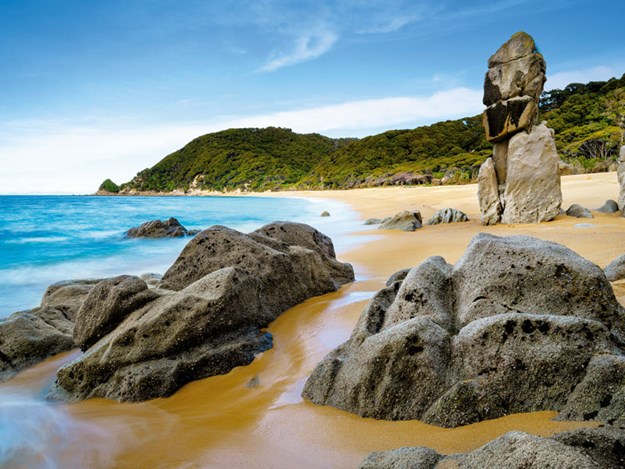
Tōtaranui to Separation Point, Abel Tasman National Park
 |
|
Separation Point |
As well as fine coastal forest and exquisite beaches, walkers get an opportunity to see kekeno (New Zealand fur seals) and pārekareka (spotted shags). Although described here beginning at Tōtaranui, Separation Point can be approached via Whariwharangi Bay, from the Wainui entrance of the park.
Tōtaranui, a popular beach and campground in the park’s north, is reached by car, bus or water taxi. Walkers can expect to see pīwakawaka (fantail), korimako (bellbird) and the ever-entertaining weka – which will skive off with your lunch if you’re not watchful. Unfortunately, during the summer and autumn, wasps proliferate in the park, so those allergic to stings should carry suitable medication.
Tōtaranui to Anapai Bay: 1 hour
From Tōtaranui, the Abel Tasman Coast Track skirts the estuary on the northern end of Tōtaranui Beach. On the far side of the estuary, the track climbs over a low saddle and down through some of the most verdant forest in Abel Tasman National Park to reach Anapai Bay. With its statuesque granite pillars, Anapai Bay is arguably the finest of all those on the Abel Tasman coastline.
- Grade: Medium
- Total walking time: 5–6 hours return
- Access: From Mārahau catch a water taxi to Tōtaranui. From Takaka, drive over Abel Tasman Drive to the Wainui Inlet, then take Tōtaranui Road. At Tōtaranui there is a large camping area, toilets and an information shelter. Alternative route: From Separation Point, energetic walkers could return to Tōtaranui via Whariwharangi Bay and the Gibbs Hill Track. This would take a full day of 7–8 hours. Alternatively, approaching Separation Point from the park’s Wainui entrance, and walking via Whariwharangi Hut, will take 6 hours return.
Find more short walking tracks in Day Walks in New Zealand by Shaun Barnett, available now from good book sellers. Published by Potton & Burton. RRP $49.99.
Find motorhomes for sale in NZ