In this extract from Lonely Planet’s Best Day Walks New Zealand, we bring you six of the South Island’s gorgeous walks. We’ll feature walks from the North Island next.
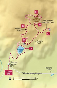
DIAMOND LAKE & ROCKY MOUNTAIN
Duration: 3 hours
Difficulty: Easy-moderate
Distance: 7km
Terrain: Good trail with a 450m climb and descent
Start/End: Diamond Lake car park
This low-level hill climb past a beautiful lake to the summit of Rocky Mountain offers lovely views over Lake Wanaka, the mouth of the Matukituki River and a distant Tititea/Mt Aspiring. The walk effectively takes in three conjoined loops; walking the central loop anticlockwise to the Lake Wanaka viewpoint, as described here, provides the most gentle ascent.
GETTING HERE
The large car park at the start of the walk is on the Wanaka–Mt Aspiring Rd, 18km west of Wanaka. The road is sealed all the way. Shuttle buses from Wanaka stop by on their way to Raspberry Flat for the Rob Roy Track – check for the latest at the Mt Aspiring National Park Visitor Centre in Wanaka.
STARTING POINT
Cross the stile at the end of the car park and enter the Diamond Lake Conservation Area.
01 The old road climbs quickly to a plateau to arrive at the willow-ringed shores of Diamond Lake. Stay on the left side of the lake. As you arrive beneath the cliffs, you’ll come to a junction. Save the lake track for later by continuing straight ahead on the track signed to Rocky Mountain, rising to the base of the cliffs and then up a long flight of steps to a wooden lookout platform (30 minutes from the car park) directly above Diamond Lake.
02 The track continues to climb. At the next junction, a couple of minutes past the lookout, keep right, following the path signed to the viewpoint. In another 10 to 15 minutes, detour right to the Lake Wanaka Viewpoint, where a seat at the mountain’s edge stares out over the lake and across Glendhu Bay to Roys Peak.
03 Return to the main track and turn right. The track swings left, zigzagging steeply up the slopes, crossing a gully and then climbing steeply on a rugged section of track. The going quickly flattens out as you reach another high plateau.
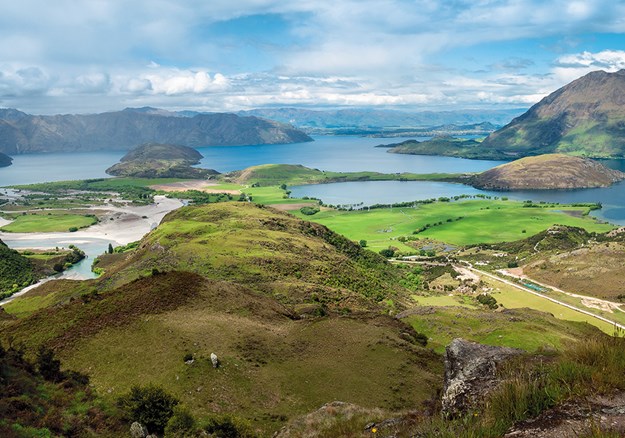
04 Turn right onto the Eastern Track, climbing through the final rack of bluffs towards the summit. There are fine views as the trail creeps along the mountain’s edge, but the grandstand view comes at the summit (775m; 1½ hours from the car park), as the scene peels open to reveal a cavalcade of features: Lake Wanaka, Treble Cone, Twin Falls and ahead, through the Matukituki Valley, the serrated summit of Tititea/ Mt Aspiring.
05 Instead of returning on the same track, continue ahead onto the Western Track, which descends gently, rounds a couple of notches in the cliffs and then curls down to the high plateau. At the junction here, turn right (signed ‘western track’), heading to the western edge of the mountain. The track descends through a damp gully, with a noticeable change in vegetation, cutting at times beneath overhanging cliffs. A steep set of tight switchbacks delivers you back to the track junction just above the Diamond Lake lookout platform that you passed earlier.
06 Turn right, passing the lookout, and descend to the lakeshore. Turn left here, completing the lake loop before returning to the car park.
TAKE A BREAK
This is a great hike for bringing along a picnic. Get your supplies in Wanaka, then tuck into your goodies at either the Lake Wanaka Viewpoint on the way up or at the summit itself.
A BIT OF HISTORY
Though Waitaha and Kai Tahu people occupied the area around Wanaka, there was no Maori presence when the first Europeans arrived here in 1853. Wanaka Station was established in 1859, and later divided into smaller runs, including Glendhu Station, which incorporated Rocky Mountain and Diamond Lake, in 1897.
Recreational use began with the Wanaka Winter Sports Club, which used frozen Diamond Lake for ice skating from the 1950s. In the 1990s, Stuart Landsborough came up with the idea of a walking track to the summit of Rocky Mountain, which he constructed with the support of the Glendhu Station landowners.
The 106-hectare Diamond Lake Conservation Area was created in 2005.
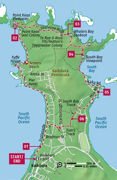
KAIKOURA PENINSULA WALKWAY
Duration: 3-4 hours
Difficulty: Easy
Distance: 11.7km
Terrain: Wide smooth paths with mostly gentle gradients
Start/End: Kaikoura i-SITE
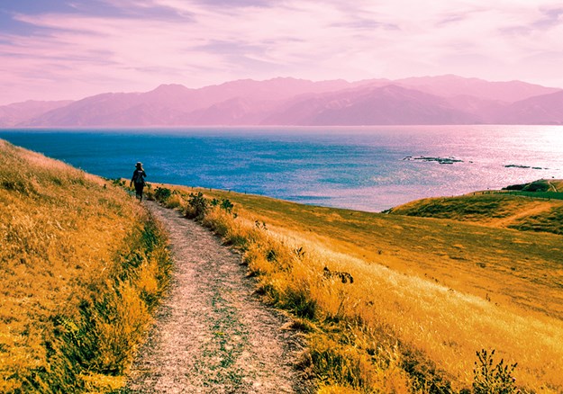
Take a walk with wildlife on this wonderful circuit of the history-rich Kaikoura Peninsula. The walk takes in a seal colony and wraparound coastal views from the peninsula’s clifftops. The seals are the stars of the show, but the walk is highly scenic in its own right.
STARTING POINT
The walk begins at the i-SITE (there’s a large display on the walkway inside) in Kaikoura’s town centre. There’s metered all-day parking on the i-SITE’s northern side.
01 Kaikoura’s most famous feature is its abundance of marine wildlife, and it extends to this walk as you set out from town along the Esplanade towards a seal colony. Pass through the whalebone arches in Anzac Park and along the edge of the town’s stony beach. At times, you’re on a footpath; other times just the road verge (but well removed from traffic). Information boards detail local history. Just beyond the beach, you’ll come to the 1885-built Pier Hotel, where you veer right into Avoca St.
02 Avoca St wriggles around the coast, becoming Fyffe Quay beside the former whaling station of Fyffe House. A final section of roadside boardwalk ends at the large Point Kean car park. This is the site of a colony of New Zealand fur seals. Take some time to wander out onto the rock platforms, among the colony, but keep 10m between yourself and any seals.
03 Cross through the car park and make the short steep climb to the Point Kean Viewpoint, overlooking the seal colony. The clifftop section of the walkway begins here, providing continual ocean views as you walk. Past the predator proof fence of the Te Rae O Atou Titi/ Hutton’s shearwater colony, you’ll come to Whalers Bay Lookout. If you want to revisit the shores, there’s a short track down from here.
WILDLIFE TOURS
Kaikoura’s stock-in-trade for tourism is wildlife tours. Few places in the world are home to such a variety of easily spottable marine life, with an upwelling of nutrients from the ocean floor created as the southerly ocean current hits the continental shelf just offshore. On offer are whale-watching tours, dolphin-watching tours and albatross-viewing tours. You can kayak or snorkel with seals and spot whales from the air. Get a full rundown on the town’s official website, kaikoura.co.nz.
04 The walkway now crosses a stile and skirts around a high headland. Across the next stile, the track turns right, but if you turn left, you can follow a side track up to the top of a bluff and an old pa site with views over South Bay and Whalers Bay. Continue down to the South Bay Viewpoint platform, which, as the name on the tin suggests, has views across South Bay to the Kaikoura Range.
05 Keep descending towards South Bay, following the roads closest to the shore, passing the boat ramp and marina. Continue on Moa Rd (despite the ‘no exit’ sign) to cut across a boat and trailer parking area to South Bay Parade, turning right at the blue walker sign to join the South Bay Track.
06 The final section of the walkway climbs through pine forest to cross the peninsula’s ridge. Atop the ridge, swing right onto Tom’s Track and descend into town. Head straight down Brighton St to the Esplanade, turning left to return to the i-SITE.
TAKE A BREAK
Situated in a primo seaside spot at 1 Avoca St, 2.5km along the walk, the Pier Hotel has a menu ruled by cray sh and paua (abalone). Lunch $15-36, dinner $24-36. Open 11am-late 03-319 5037, thepierhotel.co.nz
PUNAKAIKIPORORARI LOOP
Duration: 3-4 hours
Difficulty: Easy
Distance: 11.5km
Terrain: Undulating well-maintained track
Start/End: Waikori Road car park
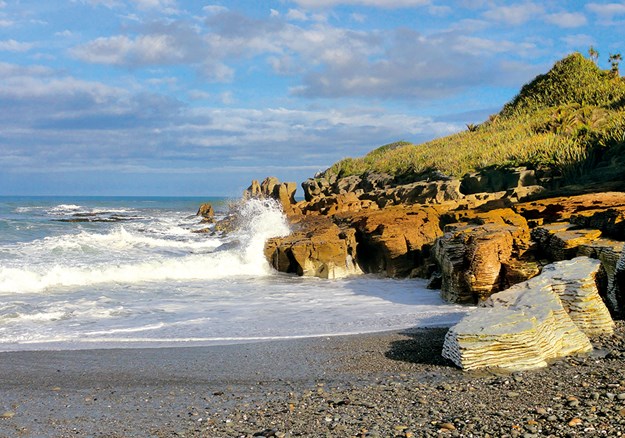
This popular walk in Paparoa National Park heads up the bouldery Punakaiki River, pops over a hill and comes down the Pororari River with its spectacular limestone gorge to rejoin the highway near the sea. From there, it’s an amble along the road to Pancake Rocks and Paparoa National Park Visitor Centre, then back to wherever you left your car. A feature of the area is the numerous nikau palm trees.
GETTING HERE
Punakaiki is 45km north of Greymouth and 56km south of Westport. The DOC Paparoa National Park Visitor Centre is directly opposite the entrance to Pancake Rocks.
STARTING POINT
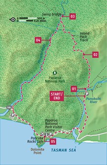
There are three starting point options – at the car park by the DOC Paparoa National Park Visitor Centre, 1km north at the mouth of the Porarari River, and 2.5km southeast at the car park on Waikori Rd. Choose whichever you like and walk the loop in either direction. e described walk is anticlockwise from the Waikori Rd car park.
01 From the Waikori Rd car park, follow the Inland Pack Track, crossing the Punakaiki River on the footbridge. This historic track, carved by gold miners in 1867 to bypass the rugged coast is, these days, a popular two-day, 25km hike – the day walk described here takes in the first part of the Inland Pack Track.
02 After crossing the bridge, head northeast, following the large orange track markers. The track passes through logged swamps to the base of the hill that separates the Punakaiki River from the Pororari Valley to the north. A well-benched track climbs through mature rainforest to a low saddle and then drops gently into the Pororari Valley.
03 When you hit a signposted junction, head upstream along the Inland Pack Track for a short distance to the swing bridge for a lovely spot to take a break.
04 Head back downstream and carry on out towards the coast from the track junction. The trail follows the river closely along its south bank, through a spectacular landscape of towering limestone bluffs graced by nikau palms and tree ferns. Keep an eye on the river’s deep-green pools for trout or eels, or perhaps you might feel inclined to take a dip at one of the spots where there is easy access to the river.
05 When you hit SH6 and the Pororari River Track car park, turn left and a 10-to15-minute walk will take you to Paparoa National Park Visitor Centre. From there, it is a 2.5km walk back along the road to the car park at the described starting point. Walkers can use the SH6 bridge over the Punakaiki River on the upstream side.
TAKE A BREAK
Almost inevitably, pancakes are the pride of the menu at Pancake Rocks Cafe opposite Pancake Rocks trail. The conservatory area – all wooden benches and fairy lights – is a pleasant spot for a drink around sundown. Visit pancakerockscafe.com to view the menu and hours. 03 731 1122 4300 Coast Rd (SH6), Punakaiki
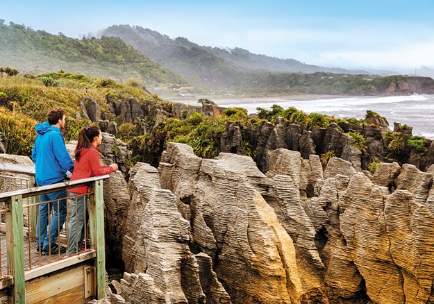
PANCAKE ROCKS
Whatever you do, before, after or during your walk, don’t forget to head out to Pancake Rocks. Punakaiki’s claim to fame is Dolomite Point, where a layering-weathering process called stylobedding has carved the limestone into what looks like piles of thick pancakes.
Aim for high tide (tide timetables are posted at the visitor centre; hope that it coincides with sunset) when the sea surges into caverns and booms menacingly through blowholes. See it on a wild day and be reminded that Mother Nature really is the boss.
Allow 20 to 30 minutes for the straightforward walk, which loops from the highway out to the rocks and blowholes (longer if you want to take photos). Parts of the trail are suitable for wheelchairs.
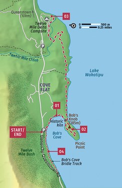
BOB’S COVE
Duration: 1-3 hour options
Difficulty: Easy
Distance: 4km
Terrain: Undulating, well-maintained track
Start/End: Bob’s Cove car park
There are some magic hiking options for families at Bob’s Cove, only a 15-minute drive from Queenstown. Take the kids on a one-hour jaunt to the beach and Bob’s Knob, or add an hour for the Bob’s Cove Bridle Track. Consider walking a couple of hours down to Twelve Mile Delta and back.
GETTING HERE
Drive southwest out of Queenstown on the road to Glenorchy at the head of Lake Wakatipu. Pass Wilson’s Bay, Twelve Mile Delta and, about 15 minutes from Queenstown, Bob’s Cove car park is on your left.
STARTING POINT
The start of the track is at the far end of Bob’s Cove car park.
01 To do the easy walk with kids, turn left and down through the beech forest almost immediately on leaving the car park. Ten minutes will bring you down to the gorgeous, pristine, pebbly beach – a great spot for kids to learn to skip stones or take a swim. Bob’s Knob is the little 385m ‘mountain’ not far to the south; lake level is around 310m above sea level. From the beach, head back onto the track for five minutes to reach an historic 1870s lime kiln. Gum trees were planted here to use as fuel for the kiln and some have grown to massive proportions in the ensuing years.
02 A few minutes further on, you’ll pass a jetty down on your right. There are marvellous examples of the lancewood tree along this shore, with the long spiky leaves of the juveniles changing to the shorter, rounder leaves of the adult as the tree grows in height. Don’t turn left at the track junction, but carry on around the shoreline of the peninsula. The track will gradually turn back on itself at Picnic Point, before making a scramble up to the top of Bob’s Knob (385m). There are stunning views from here and it makes a great picnic spot.
03 Make the short scramble down the other side, and if you’ve had enough, take the track back to Bob’s Cove beach from near the jetty you already passed; make your way back to the beach and car park. If you’re up for more, after scrambling down off Bob’s Knob, follow the coastal track along the edge of Lake Wakatipu for an hour to Twelve Mile Delta, a popular Lord of the Rings filming location. Along the way, you’ll find a couple of beaches, beautiful native forest and possibly fossils of oyster shells and other molluscs at Farry’s Beach. Allow two hours to walk down to Twelve Mile Delta and back.
04 A possible addition to the walk, either at the start or end of your adventure, is to wander along the Bob’s Cove Bridle Track, part of the original track linking Queenstown with Glenorchy. The trail from the car park is well marked along the northern side of Bob’s Cove and includes stands of massive red beech trees. Keep your eyes open for kereru (native pigeon).
TAKE A BREAK
A natural place for liquid refreshments after a walk at Bob’s Cove is 1876, the bar that now occupies Queenstown’s old courthouse, built in, you guessed it, 1876. Lime mortar from Bob’s Cove was used between the stone blocks. Inside, you’ll nd the old judge’s bench, while if you sit outside on the terrace, you can admire the ‘Trees of Justice’, two massive wellingtonia (sequoia) trees planted in the 1870s to provide shade for those awaiting justice. Open noon-late Mon-Sat, to midnight Sun. 03 409 2178, 45 Ballarat St, 1876.co.nz
BOB FORTUNE
Bob’s Cove is named after Bob Fortune, a boatman for Queenstown founder William Rees in the 1860s, and is one of the bestpreserved examples of Lake Wakatipu’s coastal past. It’s believed that between 20 and 40 million years ago the ocean penetrated from the southwest as far as the Wakatipu, and terraces around Bob’s Cove contain fossils and shells, as well as bands of mottled limestone. Maori used the cove (Te Punatapu) as a campsite while on pounamu (greenstone) expeditions, and later the Wakatipu Lime Company built seven lime kilns here in the 1870s. Lime mortar was used in building the old Queenstown courthouse and the Kawarau River suspension bridge.
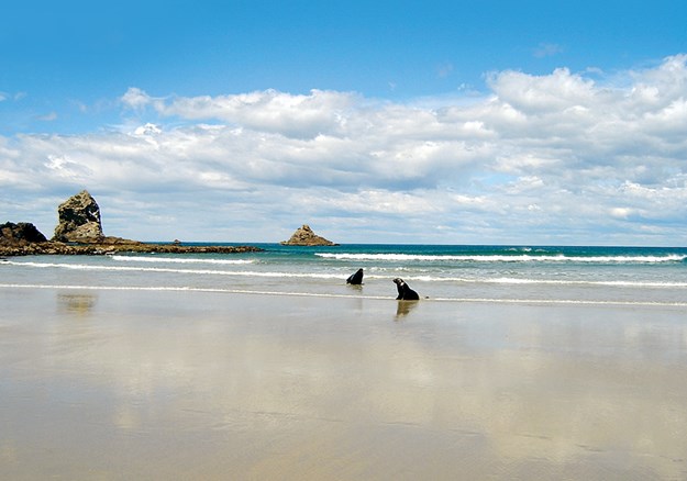
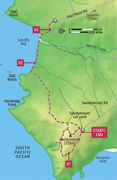
SANDYMOUNT & SANDFLY BAY
Duration: 3.5 hours
Difficulty: Easy-moderate
Distance: 7km
Terrain: Sandy, well-de ned trails
Start/End: Sandymount car park
Otago Peninsula, within close proximity of Dunedin, o ers some excellent walking options. Two that can be done separately or linked into one hike are Sandymount and Sand y Bay. For a longer hike, walk the onehour Sandymount Loop Track with its spectacular views, followed by the 2½-hour return track from Sandymount down to Sand y Bay. An easier option, with two separate hikes, is to drive to the Sandymount car park, walk the Sandymount Loop Track, return to your car, drive to the car park at the end of Seal Point Rd and walk down to Sand y Bay and back.
GETTING HERE
Both Sandymount Rd and Seal Point Rd are turns southeast off Highcliff Rd, the road that runs along the top of the spine of Otago Peninsula from Dunedin to Portobello. Both car parks are a 20-to- 30-minute drive from central Dunedin.
STARTING POINT
If doing this hike as a single longer hike, taking around 3½ hours, the track starts at the car park at the end of Sandymount Road. Park here and walk straight up through the stand of tall macrocarpa (Monterey cypress) trees.
01 As this track runs through private farmland, it is closed from 1 September to 15 October through the lambing season. The walk is basically a hike around Sandymount (320m), which as its name suggests is a mountain of sand, covered with native scrub and flora, including flax, which lines the track to the top. Walking clockwise, initially you’ll have tremendous views over Hoopers Inlet, Allans Beach and out to Cape Saunders as you walk through working farmland, out to a new DOC viewpoint. The track then winds its way right around Sandymount, before climbing to the viewpoint at the top.
02 If you’re also walking to Sandfly Bay, descend back to just short of the car park and follow the sandy track as it winds its way down to the beach, taking around an hour. The windswept landscape is spectacular – apparently Sandfly Bay got its name from the regular strong winds ‘making the sand fly’ rather than from the pesky little insect hated by walkers. Walk as far along the beach as you like, then make the long climb back up the same track to Sandymount car park.
03 If you’re doing two separate hikes, after summiting Sandymount, carry on down to the Sandymount car park. Drive back up to Hillcliff Rd, turn left and, in less than a kilometre, turn left down Seal Point Rd and drive to the car park at the end. Initially, the track crosses farmland to a viewpoint out over the bay, then drops down through sand dunes to the beach. Walk along on the sand and return when you feel like it. Allow one to 1½ hours.
TAKE A BREAK
If you’re up for refreshments after your walk, carry on along Highcliff Rd (away from Dunedin) until it descends into the small, inland harbour village of Portobello. Here, you’ll find places such as Portobello Treats & Sweets for ice cream and milkshakes, Penguin Cafe and 1908 Cafe Restaurant for meals, and the Portobello Hotel & Bistro should you be after fish and chips and a cold beer.
LOCAL WILDLIFE
Sandfl y Bay has a small colony of yellow-eyed penguins (hoiho), though numbers are alarmingly on the decline. If you encounter a penguin on the beach keep well away and crouch down. The penguins will not come ashore if they feel threatened. New Zealand fur seals (kekeno) and sea lions (rapoka) haul out on the rocks and beach and love to wallow in the sand. Also keep well away from sleeping sea lions and if you are in a group don’t surround them. Seals and sea lions may look placid but they are powerful, wild predators and can be very dangerous if they feel you’ve come too close. Other seabirds such as spotted shags, sooty shearwaters and variable oystercatchers are also common around here.
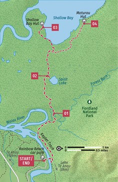
RAINBOW REACH TO SHALLOW BAY
Duration: 3 hours
Difficulty: Easy
Distance: 6km
Terrain: Mostly flat; well-maintained track
Start/End: Rainbow Reach car park
An easy walk through native forest to a beautiful beach on the shores of Lake Manapouri, this is a top walk for families and a superb taste of the Kepler Track. There’s interesting flora plus the opportunity of a lake swim at Shallow Bay. The walk can be lengthened by 3½ hours to walk back to Lake Te Anau and the end of the Kepler Track.
GETTING HERE
The track begins at Rainbow Reach, 12km south of Te Anau on the Manapouri–Te Anau Hwy. After 10.5km, turn right at the signposted road to get to Rainbow Reach car park in another 1.5km. There are shuttle buses from Te Anau during the November to April busy season.
STARTING POINT
From the car park, cross the swing bridge over the Waiau River to get onto the Kepler Track.
01 The Waiau is a popular fishing river, loaded with rainbow and brown trout, so keep your eyes open as you cross the swing bridge. When you’re on the Kepler Track, it follows the river through mature beech forest, occasionally offering lovely river views until, after half an hour or so, you cross the Forest Burn, a small tributary of the Waiau, on a swing bridge.
02 After another 20 minutes or so, you’ll reach the Amoeboid Mire, a wetland with an interesting short side track on boardwalk out to the Spirit Lake viewing platform which has information panels. The wetland and lake are on a terrace that formed as the Manapouri glacier melted. Expect wetland vegetation such as sphagnum moss, a wide variety of other mosses, wire rush and a range of herbs and shrubs. When there’s no wind, the lake has great mountain reflections.
03 Back on the main track, 10 minutes after another section of boardwalk over part of the wetland, head left at the signed turn-off to Shallow Bay. You’ll reach the beach 15 minutes later. Make sure to head around the pebbly beach and poke your nose into the DOC’s tiny six-bed Shallow Bay Hut – and if it’s warm, take a dip in the lake. This is a great spot for a picnic if you’ve brought supplies.
04 For some extra exploring, back at the junction, turn left to walk to the DOC’s impressive 40-bed Moturau Hut, also close to the lake’s foreshore, in another 20 minutes. This is where most Kepler walkers spend their last night before walking out to Lake Te Anau. If you came by shuttle and don’t have a vehicle at Rainbow Reach car park, consider lengthening your walk by 3½ hours and following the Kepler Track all the way up the western side of the Waiau River to Lake Te Anau and the start/end of the Kepler Track. Otherwise, follow the trail back to the Rainbow Reach swing bridge and car park.
TAKE A BREAK
Picnic supplies can be purchased in Te Anau or Manapouri. When you have finished with walking, head to The Church in Manapouri – an 1885-built former Presbyterian Church that has been converted into a merry pub with exceptionally welcoming staff. This popular place serves up pub fare and refreshingly cold beer. Though there aren’t a lot of options in Manapouri, Cathedral Cafe is next door.
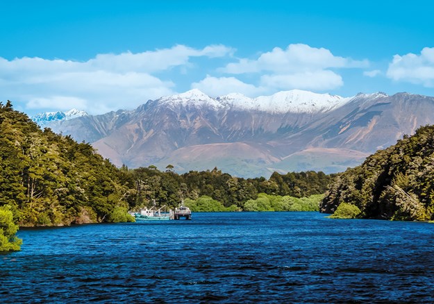
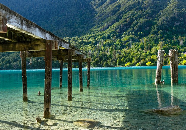
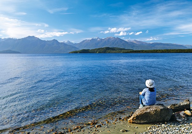
LAKE MANAPOURI
The small town of Manapouri, 20km south of Te Anau, is the jumping-off point for cruises to Doubtful Sound. It sits at the southeast corner of Lake Manapouri – NZ’s fifth-largest and second-deepest lake – which holds a special place in the history of the country’s conservation movements. In the late 1960s and early 1970s, determined conservationists mounted a successful ‘Save Manapouri’ campaign against a scheme to raise the level of the lake by 30m as part of a hydroelectric power development. This was seen as a major win for conservationists – and with 34 islands, forested lakeshores and mountainous surrounds, Lake Manapouri is arguably one of the most beautiful lakes in the country.
Lonely Planet’s Best Day Walks New Zealand is available where all good books are sold. RRP $36.99