Scattered along a remote beach on the Hokianga Harbour, the Koutu Boulders are concretions, formed like the famous Moeraki Boulders from a hard core within sedimentary rocks. A cementing mineral binds the stones together, and they gain their round shape over millennia, probably by being rolled around on the ocean floor.
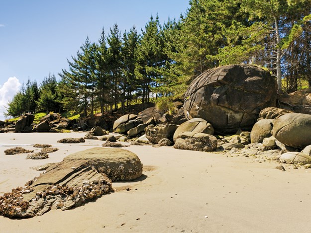
The largest of Koutu’s boulders may have taken five million years to form. The rocks have been described as giant cannonballs or bowling balls, and you have to see them to appreciate their size and variety. Each time Malcolm and I have visited the Koutu Boulders we’ve been alone among the spheres, so it was a surprise to see two other people there when we visited recently.
The couple were German tourists, who said they were intent on discovering places off the beaten tourist trail. When I told them that many New Zealanders, including those who live relatively close by, had never heard of the boulders they were surprised.
A secret beach
The Koutu Boulders are probably not well known because they are in a quiet corner of the Hokianga. Nearby Opononi became famous in the 1950s when a dolphin nicknamed Opo delighted visitors to the harbour. Opononi and its neighbour Omapere are still tourist destinations - their sandy beaches are easily accessed from SH12.
Still, most people don’t realise the harbour has other lovely beaches not far from the main road. To get to the boulders, turn off onto Koutu Loop Road. Near the beach, there’s a short side road (Waione Road) that leads to a small parking area. The beach is beautiful. Because the boulders are best accessed at low tide, we timed our visit accordingly and were treated to an expanse of golden sand as we wandered along admiring the view.
The water was calm, reflecting the high sandy dunes of Hokianga’s North Head and the pudding-shaped islet that resembles a giant semi-submerged boulder. Along the harbour, we could see distant views of the bush-clad mountains of the north Hokianga.
Among the giants
The boulders are clustered above the high tide line, many a good 3m in diameter, though the giants at the far end of the beach were as large as 5m and towered over us. Some were perfectly spherical, others kina-shaped.
A few of the boulders had split open like segments of an orange. Another had fallen into two halves with its core revealed like a stone in a giant peach. The German tourists pointed out one they said looked like a colossal face: a little imagination turned the boulder into a troll’s head.
New Zealands third-oldest settlement
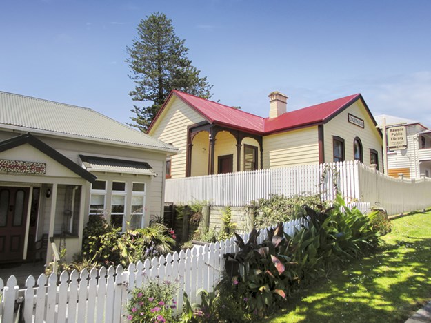 |
Rawene is full of pretty old buildings |
The Hokianga Harbour is said to have been first discovered by the Polynesian explorer Kupe. Its original name was Te Hokianga-a-Kupe, the returning place of Kupe. Legends tell that when he sailed back to Hawaiki, he left behind two taniwha (water spirits) to guide the safe landings of those who followed in his footsteps.
Indeed, the bar at the Hokianga Harbour entrance discouraged early European shipping, though some braved the waters to fell the timber that grew densely along its banks. One of the first to discover this timber was Captain James Herd who bought land in the 1820s at what became known as Herd’s Point.
By the 1860s, the area had been divided up, and the place was renamed the Hokianga Township. Twenty years later, the growing settlement was given the name Rawene. Timber milling continued until 1928, but the settlement’s reliance on water transport faded with the development of roads. However, a ferry still plies the waters to Kohukohu on the harbour’s north side.
After parking by the waterside in Rawene, we headed for our favourite café in the town, The Boatshed, on Clendon Esplanade. The food and service are excellent - Rawene may be a small place, but it is far from unsophisticated. The art and crafts in the local shops are well worth taking a look at while you’re there.
Geological wonders
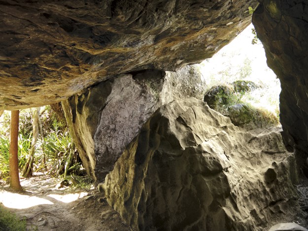 |
The path took us beneath huge rocks |
Close to the head of the harbour, near the tiny settlement at Horeke, are the Wairere Boulders. Unlike the concretions at Koutu, these are far from spherical. Instead, the jumbled monsters that fill the valley are ridged and scored dramatically. Once, these basalt rocks (formed by lava from an eruption at the site of Lake Omapere 2.8 million years ago) were beneath a kauri forest.
Over time, rainfall through the kauri became acidic and eroded the rocks below. Later, the stones cracked and broke apart, while the underlying soil washed away. The stranded boulders, some nearly 10m high, are thought to be unique.
Felix and Rita Schaad created the Wairere Boulders Nature Park in the early 2000s. They built paths through, over and around the boulders, adding quirky signage and making the valley magical for young and old alike with painted rocks and fairy houses.
 |
At Wairere Boulders |
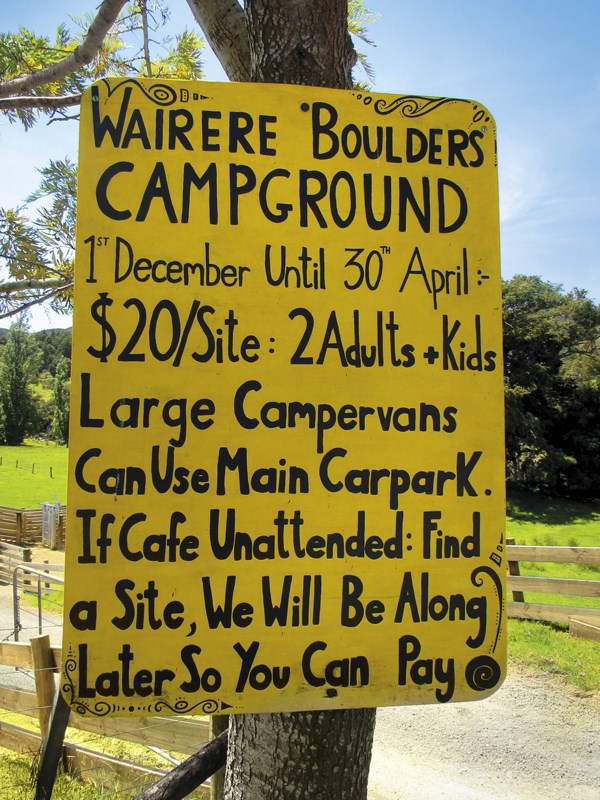
Since 2017, the Grant family has become ‘Team Boulder’, taking over from the Schaads. The Grants have expanded the experience at Wairere Boulders by adding a campground, B&B accommodation and a small café.
Our recent visit recalled our first years ago. This time, just like then, there was no one else around, and we left our entrance fee in an honesty box. After investigating the camping area and browsing the photos and stories in the info shed, we set off to do the loop walk.
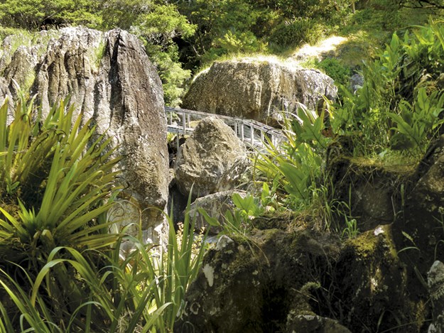 |
On the loop walk |
This easy track will take you over bridges, along boardwalks, up and down stairs and, somewhat disconcertingly, under massive boulders that were balanced one upon another. Along the way, we spotted ‘boulder beasts’ and fairy doors, as well as enjoying the lovely bush. We took a side-track to the swimming hole. It looked tempting, but we didn’t have togs with us - something to remember for a future visit.
The Boulder Loop took us about an hour. We could have headed off on the longer Lookout Track or the Magic Rock Tramp, but the day was hot and cold drinks were calling, so we returned to the car park and bid the Hokianga Harbour farewell for now. Like Kupe, we’ll be returning before too long.
further information
- The Koutu Loop Road is about 6km from Opononi or, if coming from Kaikohe, it’s about 10km past the Rawene turn. There is another entrance to the beach at Cabbage Tree Bay Road further along Waione Road, but we haven’t parked there. Bear in mind these roads are narrow and unsealed.
- More information about the Koutu Boulders and other places of interest on the Hokianga Harbour can be found at hokianga.com
- Wairere Boulders is near Horeke. About 2km along the Taheke-Horeke Road there’s a turn onto McDonnell Road. The boulders are about 500m further on at the end of the road. The website, wairereboulders.co.nz, has information and details. Camping there is from 1 December to Easter, with free overnight parking when you pay to enter the boulders.
- We’ve heard there is a camping area at Koutu called Koutu Mangeroa; basic but cheap and with great views. Rawene has a holiday park with power sites.